|
|||||||||||||||||||
| Miles measured from Allandale | Facing North | Facing South | |||||||||||||||||
| Mileage referenced in GTR Timetable 1893 | |||||||||||||||||||
| Mileage referenced in GTR Timetable No. 4 June 28, 1914 | |||||||||||||||||||
| CN Timetable 1943, Table 172 | |||||||||||||||||||
| CN Timetable No. 60 1973 | |||||||||||||||||||
| CN Timetable No. 43 1981 | |||||||||||||||||||
| CN Timetable No. 48 1983 | |||||||||||||||||||
| CN Timetable No. 49 1984 | |||||||||||||||||||
| CN Timetable No. 54 1986 | |||||||||||||||||||
| Barrie Collingwood Railway Timetable | |||||||||||||||||||
| BCRY is operated by Cando Contracting Limited and assumed operations in 1998 | |||||||||||||||||||
| 0.0 | 0.00 | 0.00 | 0.00 | 0.00 | Barrie | ||||||||||||||
| 0.00 | 1.30 | 0.0 | 0.0 | Allandale / Barrie | 5/19/2016 | 5/19/2016 | |||||||||||||
| 0.0 | Junction with Newmarket & Beaton Subs | ||||||||||||||||||
| 0.15 | 0.1 | 0.1 | 0.1 | 0.1 | 0.1 | Essa Road | 5/19/2016 | 5/19/2016 | |||||||||||
| 0.15 | 0.15 | 0.15 | 0.15 | 0.15 | Unknown Reference | ||||||||||||||
| 0.32 | 0.3 | 0.3 | 0.3 | 0.3 | 0.3 | Innisfil Street | 5/19/2016 | 5/19/2016 | |||||||||||
| 0.5 | 0.5 | 0.5 | 0.5 | 0.5 | Unknown Reference | ||||||||||||||
| 0.46 | 0.6 | 0.6 | 0.6 | 0.6 | 0.6 | Anne Street South | 5/19/2016 | 5/19/2016 | |||||||||||
| 0.69 | Switch | 5/19/2016 | 5/19/2016 | ||||||||||||||||
| 0.96 | Highway 400 | 5/19/2016 | 5/19/2016 | ||||||||||||||||
| 0.98 | Siding | 5/19/2016 | 5/19/2016 | ||||||||||||||||
| 1.10 | Patterson Road | 5/19/2016 | 5/19/2016 | ||||||||||||||||
| 1.30 | Towland Construction Company | ||||||||||||||||||
| 1.36 | Ferndale Drive South | 5/19/2016 | 5/19/2016 | ||||||||||||||||
| 1.50 | 1.5 | 1.5 | Yard Limit | ||||||||||||||||
| 2.99 | Old Mile Marker 23 | 5/19/2016 | 5/19/2016 | ||||||||||||||||
| 3.00 | Road 27 | 5/19/2016 | 5/19/2016 | ||||||||||||||||
| 3.64 | 11th Line | 5/19/2016 | 5/19/2016 | ||||||||||||||||
| 4.49 | 10th Line | 5/19/2016 | 5/19/2016 | ||||||||||||||||
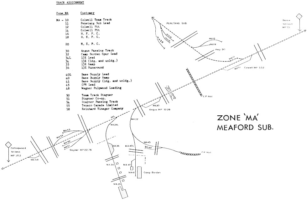
| 5.31 | Colwell Pit | ||||||||||||||||||
| 5.40 | 9th Line | 5/19/2016 | 5/19/2016 | ||||||||||||||||
| 5.45 | Switch MA 10 Team Track - South Switch | 5/19/2016 | 5/19/2016 | ||||||||||||||||
| 5.5 | 5.5 | Colwell Jct. | |||||||||||||||||
| 5.52 | 6.80 | 5.5 | 5.5 | 5.5 | 5.5 | 5.5 | 5.5 | Colwell | |||||||||||
| 5.54 | 5.6 | Junction Penetang Subdivision | |||||||||||||||||
| 5.6 | 5.6 | 5.6 | 5.6 | Penetang Spur - Extends 11.6 Miles Northward | |||||||||||||||
| 5.6 | 5.6 | Penetang Spur - Extends 2.0 Miles Northward | 5/19/2016 | 5/19/2016 | |||||||||||||||
| 5.87 | Switch MA 10 Team Track - North Switch | 5/19/2016 | 5/19/2016 | ||||||||||||||||
| 6.30 | 8th Line | 5/19/2016 | 5/19/2016 | ||||||||||||||||
| 6.35 | Sign | 5/19/2016 | 5/19/2016 | ||||||||||||||||
| 6.38 | Sign | 5/19/2016 | 5/19/2016 | ||||||||||||||||
| 7.11 | Road 56 | 4/18/2016 | 4/18/2016 | ||||||||||||||||
| 7.12 | Siding 1 | 4/18/2016 | 4/18/2016 | ||||||||||||||||
| 7.14 | Siding 2 | 4/18/2016 | 4/18/2016 | ||||||||||||||||
| 7.31 | Siding - CPR Connecting Track | 4/18/2016 | 4/18/2016 | ||||||||||||||||
| 7.32 | Signal 75 | 4/18/2016 | 4/18/2016 | ||||||||||||||||
| 7.44 | 8.3 | 7.5 | 7.5 | 7.5 | 7.5 | 7.5 | Crossing CPR Mactier Subdivision Mile 58.09 | 4/18/2016 | 4/18/2016 | ||||||||||
| Mile 7.5 to Mile 30.4 Out of Service July 15th, 2011 | |||||||||||||||||||
| 7.65 | Siding - CPR Connecting Track - Abandoned | 4/18/2016 | 4/18/2016 | ||||||||||||||||
| Signal 76 | 4/18/2016 | 4/18/2016 | |||||||||||||||||
| 8.01 | 8.9 | 8.0 | Utopia | ||||||||||||||||
| 8.04 | 6th Line | 4/18/2016 | 4/18/2016 | ||||||||||||||||
| 8.87 | Line 5 | 4/18/2016 | 4/18/2016 | ||||||||||||||||
| 9.6 | 9.6 | Yard Limit | |||||||||||||||||
| 9.78 | 9.7 | 9.7 | 9.7 | 9.7 | 9.7 | Bridge - Nottawasaga River | |||||||||||||
| 9.91 | Alma Street | 4/18/2016 | 4/18/2016 | ||||||||||||||||
| 9.95 | Siding - South Switch - Passing Track | 4/18/2016 | 4/18/2016 | ||||||||||||||||
| 10.00 | Mile 10 | 4/18/2016 | 4/18/2016 | ||||||||||||||||
| 10.28 | 11.70 | 10.3 | 10.3 | 10.3 | 10.3 | 10.3 | 10.3 | 10.3 | Angus | ||||||||||
| 10.35 | Siding - North Switch - Passing Track | 4/18/2016 | 4/18/2016 | ||||||||||||||||
| 10.36 | 10.4 | 10.4 | 10.4 | 10.4 | 10.4 | Cross Street | 4/18/2016 | 4/18/2016 | |||||||||||
| 10.46 | 10.4 | 10.4 | C.F.B. Borden Spur - Extends 4.0 Miles West - Removed by 1983 | 4/18/2016 | 4/18/2016 | ||||||||||||||
| 10.58 | Bridge - The Pine River | 4/19/2016 | 4/19/2016 | ||||||||||||||||
| 10.65 | Mill Street | 4/19/2016 | 4/19/2016 | ||||||||||||||||
| 10.80 | 10.8 | Yard Limit | |||||||||||||||||
| 11.20 | 11.2 | 11.2 | 11.2 | Depot Track 13X - Extends 1.2 Miles West | |||||||||||||||
| 11.2 | 11.2 | Depot Track MA34 - Extends 1.2 Miles West | |||||||||||||||||
| 11.68 | Bridge | ||||||||||||||||||
| 12.05 | Sunnydale - Tosorontio Townline | ||||||||||||||||||
| 13.0 | 13.4 | Brentwood | |||||||||||||||||
| 13.45 | McCarthy Drive | ||||||||||||||||||
| 14.04 | Concession Rd 2 Sunnidale | ||||||||||||||||||
| 14.53 | Sideroad 12 & 13 Sunnidale | ||||||||||||||||||
| 15.60 | Road 9 | 4/18/2016 | 4/18/2016 | ||||||||||||||||
| 16.80 | 15.2 | 15.7 | New Lowell | ||||||||||||||||
| 15.95 | Greengage Rd | ||||||||||||||||||
| 16.15 | Concession Rd 5 Sunnidale | ||||||||||||||||||
| 16.8 | Sunnidale | ||||||||||||||||||
| 16.96 | Creemore Avenue | ||||||||||||||||||
| 17.78 | Sideroad 6 & 7 Sunnidale | ||||||||||||||||||
| 18.26 | Concession Rd 7 Sunnidale | ||||||||||||||||||
| 19.40 | Sideroad 3 & 4 Sunnidale | ||||||||||||||||||
| 20.40 | Concession Rd 9 Sunnidale | ||||||||||||||||||
| 21.00 | Center Line Road | 4/11/2016 | 4/11/2016 | ||||||||||||||||
| 21.40 | Sideroad 21 & 22 Nottawasaga | 4/11/2016 | 4/11/2016 | ||||||||||||||||
| 21.66 | Fletcher Road | 4/11/2016 | 4/11/2016 | ||||||||||||||||
| 22.54 | Siding | 4/11/2016 | 4/11/2016 | ||||||||||||||||
| 22.56 | Superior Street | 4/11/2016 | 4/11/2016 | ||||||||||||||||
| 22.58 | Siding - Passing Track - South Switch | 4/11/2016 | 4/11/2016 | ||||||||||||||||
| 21.8 | Bridge ? | ||||||||||||||||||
| 22.76 | Siding | 4/11/2016 | 4/11/2016 | ||||||||||||||||
| 22.79 | Siding - Passing Track - North Switch | 4/11/2016 | 4/11/2016 | ||||||||||||||||
| 22.8 | 22.8 | 22.8 | 22.8 | 22.8 | 22.8 | 22.8 | Stayner | ||||||||||||
| 22.80 | Highway 26 | 4/11/2016 | 4/11/2016 | ||||||||||||||||
| 23.38 | Highway 26 | 4/11/2016 | 4/11/2016 | ||||||||||||||||
| 24.20 | Sideroad 27 & 28 Nottawasaga | 4/11/2016 | 4/11/2016 | ||||||||||||||||
| 25.60 | Sideroad 30 & 31 Nottawasaga | 4/11/2016 | 4/11/2016 | ||||||||||||||||
| 25.70 | Fairgrounds Road North | 4/11/2016 | 4/11/2016 | ||||||||||||||||
| 27.00 | Sideroad 33 & 34 Nottawasaga | 4/11/2016 | 4/11/2016 | ||||||||||||||||
| 28.15 | 28.1 | 28.2 | Batteaux | ||||||||||||||||
| 28.10 | Bridge | ||||||||||||||||||
| 28.14 | Concession Road 6 | ||||||||||||||||||
| 28.43 | Nottawa Side Road | ||||||||||||||||||
| 29.71 | End of Steel 2016 | ||||||||||||||||||
| 29.72 | Poplar Sideroad - | ||||||||||||||||||
| 29.80 | 29.8 | Bridge | |||||||||||||||||
| 29.85 | Start of Steel | ||||||||||||||||||
| 30.20 | 30.2 | 30.2 | Yard Limit | ||||||||||||||||
| 30.4 | 30.4 | 30.4 | 30.4 | 30.4 | 30.4 | Pretty River Spur - Extends 0.9 Miles Eastward | |||||||||||||
| 30.41 | End of Steel | ||||||||||||||||||
| 30.42 | Collins Street | ||||||||||||||||||
| 30.61 | Manning Avenue - Steel removed 2016 | ||||||||||||||||||
| 30.9 | 30.9 | 30.9 | 30.9 | 30.9 | Hume Street | ||||||||||||||
| 31.2 | 31.2 | 31.2 | 31.2 | 31.2 | 31.2 | Ontario Street | |||||||||||||
| 31.2 | 31.2 | 31.2 | 31.2 | 31.2 | 31.2 | Switch Collingwood Spur | |||||||||||||
| 31.4 | 32.6 | 31.4 | 31.4 | 31.4 | 31.4 | 31.4 | 31.4 | 31.4 | Collingwood | ||||||||||
| 31.4 | 31.4 | 31.4 | 31.4 | 31.4 | Pretty River Parkway | ||||||||||||||
| 31.4 | 31.4 | 31.4 | 31.4 | 31.4 | 31.4 | Huron Street | |||||||||||||
| 31.4 | End of Subdivision in Timetable No. 54 1986 | ||||||||||||||||||
| 31.71 | North Maple Street | 4/17/2016 | 4/17/2016 | ||||||||||||||||
| 31.86 | Birch Street | 4/17/2016 | 4/17/2016 | ||||||||||||||||
| 31.93 | 32.0 | Bridge | 4/17/2016 | 4/17/2016 | |||||||||||||||
| 31.94 | Oak Street | 4/17/2016 | 4/17/2016 | ||||||||||||||||
| 32.00 | 32.00 | 32.00 | Unless authorized by the Chief Train Dispatcher on instructions from the Superintendent movements must not be operated between mileage 32.0 and mileage 52.2 | ||||||||||||||||
| 32.00 | Rail lifted in 1985 between mileage 32.0 and mileage 52.2 | ||||||||||||||||||
| 32.01 | Cedar Street | 4/17/2016 | 4/17/2016 | ||||||||||||||||
| 32.08 | Bridge | 4/17/2016 | 4/17/2016 | ||||||||||||||||
| 32.1 | Lake Jct. with Beeton and Collingwood Subdivision Mile 40.85 | ||||||||||||||||||
| Jct. with Hamilton & Northwestern Railway Jct. with Alliston Subdivision mile 39.43 Walnut Street Running | |||||||||||||||||||
| Lake Junction | |||||||||||||||||||
| 32.16 | Hickory Street | 4/17/2016 | 4/17/2016 | ||||||||||||||||
| 32.24 | Spruce Street | 4/17/2016 | 4/17/2016 | ||||||||||||||||
| 32.32 | Elm Street | 4/17/2016 | 4/17/2016 | ||||||||||||||||
| 32.4 | 32.4 | 32.4 | 32.4 | 32.4 | Highway 26 | 4/17/2016 | 4/17/2016 | ||||||||||||
| 32.5 | Yard Limit | ||||||||||||||||||
| 35.40 | 35.4 | 35.4 | 35.4 | 35.4 | Osler Road Road 21 / 34 | 4/17/2016 | 4/17/2016 | ||||||||||||
| 36.56 | Lakeshore Road | 4/17/2016 | 4/17/2016 | ||||||||||||||||
| 37.15 | 37.0 | 37.2 | Craigleith Station | 4/17/2016 | 4/17/2016 | ||||||||||||||
| 37.29 | Road 19 | 4/17/2016 | 4/17/2016 | ||||||||||||||||
| 38.49 | Arrowhead Road | 4/17/2016 | 4/17/2016 | ||||||||||||||||
| 38.91 | Hidden Lake Road | 4/17/2016 | 4/17/2016 | ||||||||||||||||
| 39.38 | Wards Road | 4/17/2016 | 4/17/2016 | ||||||||||||||||
| 39.97 | Peaks Road | 4/17/2016 | 4/17/2016 | ||||||||||||||||
| 40.1 | Camperdown | ||||||||||||||||||
| 41.0 | Fields | ||||||||||||||||||
| 41.16 | Camperdown Road | ||||||||||||||||||
| 41.30 | Mail catch post | ||||||||||||||||||
| 41.72 | Road 40 | ||||||||||||||||||
| 42.89 | Highway 26 | ||||||||||||||||||
| 42.6 | 42.6 | 42.6 | 42.6 | Bridge | |||||||||||||||
| 43.67 | Gray Street North | ||||||||||||||||||
| 43.95 | Elgin Street North | ||||||||||||||||||
| 43.97 | 45.1 | 43.8 | 44.0 | 44.0 | 44.0 | 44.0 | 44.0 | Thornbury | |||||||||||
| 44.23 | Mill Street | ||||||||||||||||||
| 44.32 | 44.2 | Bridge | |||||||||||||||||
| 44.30 | 44.3 | 44.3 | 44.3 | 44.3 | Bruce Street | ||||||||||||||
| Beaver River bridge | |||||||||||||||||||
| Water tank | |||||||||||||||||||
| 44.31 | Snetsinger | ||||||||||||||||||
| 44.46 | Switch | ||||||||||||||||||
| 44.48 | Elma Street | ||||||||||||||||||
| 44.63 | King Street West | ||||||||||||||||||
| 44.77 | Landsdown Street North | ||||||||||||||||||
| 45.10 | Peel Street North | ||||||||||||||||||
| 45.70 | 10th Line | ||||||||||||||||||
| 46.06 | McNamara Construction Company | ||||||||||||||||||
| 46.15 | Rankin's Crescent East | ||||||||||||||||||
| 46.49 | Rankin's Crescent West | ||||||||||||||||||
| 46.71 | Lora Bay Road | ||||||||||||||||||
| 47.72 | Christie Beach Road | ||||||||||||||||||
| 48.28 | Christies | ||||||||||||||||||
| 49.64 | South wye switch | ||||||||||||||||||
| 49.75 | Meaford Wye | ||||||||||||||||||
| 49.87 | North wye switch | ||||||||||||||||||
| 50.38 | Swathmore Drive | ||||||||||||||||||
| 50.69 | Swathmore Drive | ||||||||||||||||||
| 51.37 | Montgomery Street | ||||||||||||||||||
| 51.4 | Yard Limit | ||||||||||||||||||
| 51.64 | St Vincent Street | ||||||||||||||||||
| 51.77 | Switch | ||||||||||||||||||
| 51.79 | Edwin Street | ||||||||||||||||||
| 51.91 | Margaret Street | ||||||||||||||||||
| 51.95 | Marshall Street | ||||||||||||||||||
| 52.10 | 52.0 | 52.0 | 52.0 | 52.0 | Boucher Street | ||||||||||||||
| 52.06 | 52.1 | 52.1 | 52.1 | 52.1 | Lake Siding Switch | ||||||||||||||
| 52.1 | 52.1 | 52.1 | 52.1 | Bridge Street | |||||||||||||||
| 52.15 | 53.1 | 52.2 | 52.2 | 52.2 | 52.2 | 52.2 | Meaford | ||||||||||||
| 52.36 | Engine service track | ||||||||||||||||||
| 52.53 | End of steel | ||||||||||||||||||
| Barrie Spur - CN Meaford Sub. | |||||||||||||||||||
| Barrie Spur extends 0.54 Miles West | |||||||||||||||||||
|
Miles from Mile 0.69 Meaford Subdivision |
Facing East | Facing Wast | |||||||||||||||||
| 0.00 | Junction with Mile 0.69 Meaford Sub | 5/19/2016 | 5/19/2016 | ||||||||||||||||
| 0.14 | Tiffin Street | 5/19/2016 | 5/19/2016 | ||||||||||||||||
| 0.15 | Switch - Removed | 5/19/2016 | 5/19/2016 | ||||||||||||||||
| 0.26 | Brock Street | 5/19/2016 | 5/19/2016 | ||||||||||||||||
| 0.27 | Switch - Western Mechanical | 5/19/2016 | 5/19/2016 | ||||||||||||||||
| 0.40 | Switch MF42 | 5/19/2016 | 5/19/2016 | ||||||||||||||||
| 0.47 | John Street -Rails removed | 5/19/2016 | 5/19/2016 | ||||||||||||||||
| 0.49 | Switch | 5/19/2016 | 5/19/2016 | ||||||||||||||||
| 0.54 | End of steel 2016 | 5/19/2016 | 5/19/2016 | ||||||||||||||||
| Pretty River Spur - CN Meaford Sub. | |||||||||||||||||||
| Pretty River Spur extends 0.9 Miles East | |||||||||||||||||||
|
|||||||||||||||||||
| Miles from Mile 30.42 Meaford Subdivision | |||||||||||||||||||
| GTR Timetable 1893 | |||||||||||||||||||
| GTR Timetable No. 4 June 28, 1914 | |||||||||||||||||||
| CN Timetable 1943, Table 172 | |||||||||||||||||||
| CN Timetable No. 60 1973 | |||||||||||||||||||
| CN Timetable No. 43 1981 | |||||||||||||||||||
|
CN Timetable No. 48 1983 |
|||||||||||||||||||
|
CN Timetable No. 49 1984 |
|||||||||||||||||||
| CN Timetable No. 54 1986 | |||||||||||||||||||
| Barrie Collingwood Railway Timetable | |||||||||||||||||||
| Mileage referenced in Barrie Collingwood Railway Timetable (BCRY assumed operations in 1998) | |||||||||||||||||||
| Facing East | Facing West | ||||||||||||||||||
| 0.00 | 0.0 | 0.00 | 0.00 | 0.00 | 0.00 | Junction with Mile 30.42 Meaford Sub | 4/17/2016 | 4/17/2016 | |||||||||||
| 0.01 | End of Steel - April 2016 | ||||||||||||||||||
| 0.02 | Collins Street | 4/17/2016 | 4/17/2016 | ||||||||||||||||
| 0.03 | End of Steel - April 2016 | 4/17/2016 | 4/17/2016 | ||||||||||||||||
| 0.23 | End of Steel - April 2016 | 4/17/2016 | 4/17/2016 | ||||||||||||||||
| 0.25 | Peel Street | 4/17/2016 | 4/17/2016 | ||||||||||||||||
| 0.35 | Bridge - Pretty River | 4/17/2016 | 4/17/2016 | ||||||||||||||||
| 0.46 | Raglan Street | 4/18/2016 | 4/18/2016 | ||||||||||||||||
| 0.62 | Switch - Canadian Mist distillery | 4/18/2016 | 4/18/2016 | ||||||||||||||||
| 0.73 | Switch | 4/18/2016 | 4/18/2016 | ||||||||||||||||
| 0.83 | Switch - Pilkington Glass | 4/30/2016 | 4/30/2016 | ||||||||||||||||
| 0.75 | Switch - East end of Passing Track | 4/30/2016 | 4/30/2016 | ||||||||||||||||
| 0.86 | Switch - West end of Passing Track | 4/30/2016 | 4/30/2016 | ||||||||||||||||
| 0.88 | 0.9 | 0.9 | 0.9 | 0.9 | 0.9 | End of Spur | 4/30/2016 | 4/30/2016 | |||||||||||
| Pilkington Spur - Pretty River Spur | |||||||||||||||||||
|
Pilkington Glass Spur extends 0.21 Miles East from Mile 0.87 Pretty River Spur, Meaford Subdivision |
|||||||||||||||||||
|
Miles from Mile 0.87 Pretty River Spur |
|||||||||||||||||||
| Facing East | Facing West | ||||||||||||||||||
| 0.00 | Switch at Mile 0.87 Pretty River Spur | 4/30/2016 | 4/30/2016 | ||||||||||||||||
| 0.04 | End of Steel - April 2016 | 4/30/2016 | 4/30/2016 | ||||||||||||||||
| 0.11 | End of Steel - April 2016 | 4/30/2016 | 4/30/2016 | ||||||||||||||||
| 0.12 | Switch | 4/30/2016 | 4/30/2016 | ||||||||||||||||
| 0.20 | End of Steel - April 2016 | 4/30/2016 | 4/30/2016 | ||||||||||||||||
| 0.21 | End of Spur | 4/30/2016 | 4/30/2016 | ||||||||||||||||
| 0.21 | Pilkington Glass Property | ||||||||||||||||||
 |
|||||||||||||||||||
 |
|||||||||||||||||||